


Principals Of Alignment
Surveying can be defined in many different ways, whether it is from an engineering or civil perspective. One definition could be that surveying is the art of measuring distances, angles and positions, on or near the surface of the earth.
It is an art in that only a surveyor who possesses a thorough understanding of surveying techniques will be able to determine the most efficient methods required to obtain optimal results over a wide variety of surveying problems. Surveying is scientific to the degree that rigorous mathematical techniques are used to analyse and adjust the field survey data. The accuracy, and thus reliability, of the survey depend not only on the field expertise of the surveyor, but on the surveyors understanding of the scientific principles underlying and affecting all forms of survey measurement.
The definition can be generalised even further when looking at the subject through an engineering perspective. To accurately survey any plant/machinery using the most accurate surveying instruments and techniques.
Evolution
As a company who specialise in surveying, we felt it fitting to give the reader some brief history into the evolution of this profession.
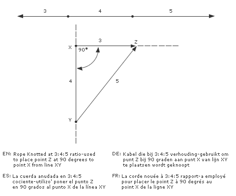
Historical records dating back almost five thousand years show evidence of surveyors in China, India, Babylon and Egypt. The Egyptian surveyor called harpedonapata (rope stretcher) was in constant demand. He and early surveyors discovered that the 3: 4: 5 ratio provided right angled triangles. To lay out X Z at 90 degrees to X Y a twelve unit rope would have knots tied at 3 and 4 unit positions as shown. One surveyor held the 3-unit knot at X, the second surveyor held the 4-unit knot at Y. The third surveyor held both loose ends of the rope and stretched the rope tightly, resulting in the location of point Z. (See FIG 1)
Another ancient surveying instrument consisted of three pieces of wood in the shape of an isosceles triangle. A plumb bob suspended from the apex of the frame would line up with a notch in the mid point of the base- but only when the base was level.
It is presumed that the great pyramids were laid out with knotted ropes, the level described here and various forms of water trough levels for the foundations.
Pythagoras was one of many famous Greek mathematicians, He and his school (about 550 bc) developed theories of geometry and numbers, they were also the first to deduce that the earth was spherical by noting the shape of the earths shadow on the moon. The word geometry derives from Greek, geometria meaning, “to measure the earth”.
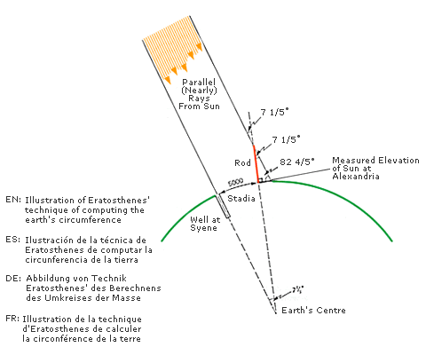
By 250 bc Archimedes had recorded in a book that the circumference of the earth was 30 myriads of stadia (i.e.; 300,000 stadia) he had received some support for this value from a colleague called Eratosthenes who was a mathematician. Eratosthenes knew of a town called Syene that was 5000 stadia due south of Alexandria (Egypt). He also knew that at summer solstice the sun was directly over Syene at noon- there were no shadows. The absence of shadows was demonstrated by noting that the suns reflection was exactly centred in the well water. Eratosthenes reasoned that at the summer solstice, the sun, the towns of Syene and Alexandria, and the centre of the earth all lay in the same plane. (See FIG 2)
At noon on the summer solstice the elevation of the sun at Alexandria was measured at 82 4/5 of a degrees- and the angle from the top of the rod to the sun was calculated at 7 1/5 degrees. Since the sun is such a long distance from the earth, it can be assumed that the suns rays are parallel as they reach the earth, with that assumption, it can be deduced that the angle from the top of the rod to the sun is the same as the angle at the earths centre – 7 1/5 degrees. Because 7 1/5 degrees is 1/50 of 360 degrees, it follows that the circular ark subtending 7 1/5 degrees (the distance from Syene to Alexandria) is 1/50 the circumference of the earth.
The circumference of the earth is thus determined to be 250,000 stadia. If the stadium being used was 1/10 of a mile, then it is possible that Eratosthenes calculated the earth’s circumference to be 25,000 miles.
Using the Clarke ellipsoid with a mean radius of 3960 miles, the circumference of the earth would actually be: C = 2 x 3.1416 x 3960= 24,881 miles. (Pretty close!)
Other Later developments:
The naturally magnetized rock – Lodestone was first used to locate magnetic north.
The Englishman – Thomas Digges first used the term Theodolite to describe and instrument graduated in 360 degrees that was used to measure angles.
Galileo invented the Telescope in 1609, the telescope attached to a quadrant allowed triangulation, a simple method of determining angles and distances.
The first Dumpy levels were devised in the first half of the 1700’s by combining a telescope with a bubble level.
Gradient Chart
| Angle | Inch Per Inch | Inch Per Foot | MM Per Metre |
|---|---|---|---|
| 1 SEC | 0.000005 | 0.00006 | 0.005 |
| 2 SEC | 0.00001 | 0.00012 | 0.01 |
| 3 SEC | 0.000014 | 0.00017 | 0.015 |
| 4 SEC | 0.00002 | 0.00023 | 0.02 |
| 5 SEC | 0.000025 | 0.0003 | 0.025 |
| 6 SEC | 0.000029 | 0.00034 | 0.03 |
| 7 SEC | 0.000035 | 0.0004 | 0.035 |
| 8 SEC | 0.00004 | 0.00046 | 0.04 |
| 9 SEC | 0.000044 | 0.00053 | 0.045 |
| 10 SEC | 0.000048 | 0.0006 | 0.05 |
| 20 SEC | 0.0001 | 0.0012 | 0.10 |
| 30 SEC | 0.00014 | 0.001 | 0.15 |
| 40 SEC | 0.00019 | 0.0023 | 0.20 |
| 50 SEC | 0.00024 | 0.0029 | 0.25 |
| 1 MIN | 0.0003 | 0.0035 | 0.30 |
| 2 MIN | 0.0006 | 0.007 | 0.60 |
| 3 MIN | 0.0009 | 0.010 | 0.90 |
| 4 MIN | 0.0012 | 0.014 | 1.20 |
| 5 MIN | 0.0014 | 0.017 | 1.50 |
| 6 MIN | 0.0018 | 0.020 | 1.80 |
| 7 MIN | 0.0021 | 0.024 | 2.10 |
| 8 MIN | 0.0024 | 0.028 | 2.40 |
| 9 MIN | 0.0026 | 0.031 | 2.70 |
| 10 MIN | 0.0029 | 0.035 | 3.0 |
| 30 MIN | 0.0086 | 0.105 | 9.0 |
| 1 DEG | 0.0175 | 0.209 | 17.50 |